
https://us02web.zoom.us/j/85204045146?pwd=B7JZ4DfXOb0agRLcEFiCeAVxnK3N0T.1

Join Zoom Meeting
https://us02web.zoom.us/j/85292272777?pwd=tbnuhnOyWsfLIubrxoGoBryq23jhYK.1
Meeting chat link
https://us02web.zoom.us/launch/jc/85292272777
Meeting ID: 852 9227 2777
Passcode: 610031
One tap mobile
+16699006833,,85292272777#,,,,*610031# US (San Jose)
+14086380968,,85292272777#,,,,*610031# US (San Jose)
Join by SIP
• 85292272777@zoomcrc.com
Join instructions
https://us02web.zoom.us/meetings/85292272777/invitations?signature=B9O63eeKsizKRLlHOjBSYziRb1DIgpaBDe238QtlijE
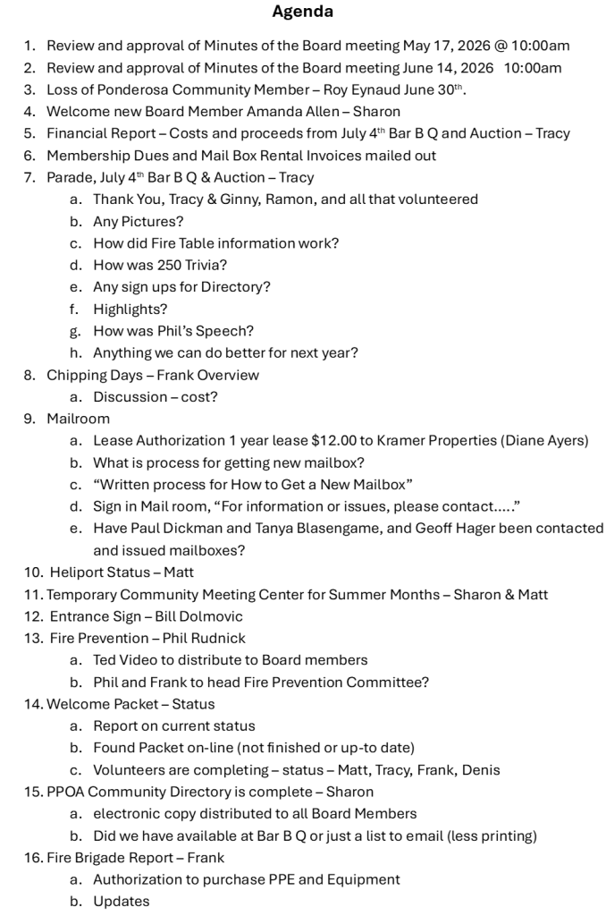
AGENDA
Invited 1tracy559@gmail.com fohne@icloud.com fohne@pacbell.net ginnyjamm@gmail.com Matt Doty phil@upstartvillage.com sharon@tcwpi.com thesierrahome@gmail.com
Board members finalized logistical plans for upcoming community events and infrastructure projects. Sharon, Phil, Frank, Tracy, Sharon and Matt were in virtual attendance. Phil and Ginny were in attendance via telephone connection.
Meeting Logistics and Governance
The board resolved technical access issues and finalized plans to switch future meetings to Zoom. Members approved meeting minutes and discussed filling board vacancies through formal outreach.
Infrastructure and Event Planning
Approval was granted for fire brigade equipment, alarm upgrades, and entry signage costs. The BoD established July 4th event schedules and refined committee responsibilities for community operations.
Community Strategy and Membership
The board decided to leverage Firewise status to incentivize property owner participation. Digital initiatives were approved for design, communication, and fundraising to enhance community engagement.
ALIGNED
● March 8th meeting minutes: A motion was made and seconded to approve the minutes of the BoD meeting held on March 8th, 2026. BoD. BoD unanimously approved the motion.
● Zoom platform adopted for meetings The BoD decided to transition to using Zoom for all future BoD meetings to resolve technical connectivity issues.
● Fourth of July event schedule set The Fourth of July event schedule is finalized with the parade starting at 10:00 AM, the barbecue at 12:00 PM, and the auction at 2:30 PM.
● Constitution trivia format established The 250th anniversary Constitution trivia contest will be conducted in a group-based ‘shout out’ format to accommodate the outdoor setting.
● Mail management policy changes The mailroom management policy is set to require a full-time resident, Matt Doty has accepted mailroom management responsibility. The responsibility for mail billing and collections is transferred to the treasurer (Tracy Landeros).
● Fourth of July celebration date The Ponderosa Fourth of July celebration is confirmed for Saturday, July 4th.
● BoD meeting scheduled for June The next BoD meeting is scheduled for June 14th at 10:00 AM at Phil’s place, with a virtual Zoom option provided.
● Entrance sign funds approved: A motion was made and seconded to allocate an additional $500 to be allocated to cover unexpected construction costs for the Ponderosa entrance sign. BoD unanimously approved the motion.
● Street sign maintenance funds approved: A motion was made and seconded to allocate a budget of up to $500 is approved for materials and installation of Ponderosa street signs. BoD unanimously approved the motion.
● Fire brigade equipment purchase approved A motion was made and seconded to purchase of fire brigade equipment for $ 6,500, using a combination of PPOA and fire brigade funds. BoD unanimously approved the motion.
● Summit fire siren funds approved A motion was made and seconded to allocate up to $500 is approved to purchase and install a replacement summit fire siren. BoD unanimously approved the motion.
● Community newsletter production discontinued The BoD decided to discontinue the production of a community newsletter, prioritizing limited resources on core community engagement.
● AI and print-on-demand strategy adopted The BoD approved shifting to an AI-generated design and just-in-time, print-on-demand strategy for merchandise and decals to generate funds without upfront costs.
● Property utilization committee established A committee consisting of Matt, Frank, and Phil was established to develop and present proposals for the utilization and protection of community property.
● Fourth of July membership drive strategy The BoD aligned on utilizing the 4th of July event as the primary venue for a membership drive, focusing on promoting Firewise benefits and infrastructure projects.
☐ [Frank Ohnesorgen] Retrieve Mail: Collect the forgotten envelope and mail early this week.
☐ [Sharon] Send Newsletters: Mail the newsletter and billing forms to the membership.
☒ [Matt Doty] Schedule Zoom Meetings: Organize all future BoD meetings using the Zoom platform.
☐ [Tracy Landeros] Prepare Fourth of July: Retrieve the notes previously managed by Tammy from the mail room to finalize event coordination.
☒ [Matt Doty] Create Trivia Questions: Draft 10 constitution trivia questions. Share ideas with Phil by next week.
☐ [Tracy Landeros] Retrieve Mailbox Records: Get current mailbox information from Tammy. Collect all paperwork from the mail room black box.
☐ [Tracy Landeros] Request Lot Cleaning: Contact Bill to ensure the lot is cleaned the week before the Fourth of July barbecue.
☐ [Matt Doty, Tracy Landeros] Plan Event Script: Collaborate on a script for the Fourth of July trivia activity. Determine the best way to frame the game for the event attendees.
☐ [Sharon] Contact Dennis: Call Dennis to confirm his intent regarding the BoD seat.
☐ [Sharon] Contact Candidates: Reach out to Sarah Dyer and Amanda Allen to gauge interest and time availability for the BoD.
☐ [Tracy Landeros] Text Mailbox Records: Capture screenshots of the collected mailbox documentation. Send the images to Sharon via text message.
☐ [Sharon] Reconcile Mailbox Lists: Coordinate the provided mailbox payment records with existing internal documentation.
☒ [Matt Doty] Setup Zoom Meeting: Organize a virtual meeting on Zoom for the BoD session scheduled on June 14.
☐ [Matt Doty, Phil] Draft Plaque Wording: Develop text for commemorative plaques and coordinate to finalize the content for review.
☐ [Sharon] Send Commemoration Details: Provide the names and details of the individuals to be commemorated to Matt Doty and Phil.
☐ [Matt Doty] Inspect Existing Plaques: Visit the commemorative shelter to inspect and document the design style of existing plaques.
☐ [Tracy Landeros] Source Cost Efficient Plaques: Research cost-efficient suppliers for new commemorative plaques.
☐ [Frank Ohnesorgen] Estimate Truck Repair: Obtain a cost estimate for replacing leaking seals on the fire truck.
☐ [Frank Ohnesorgen] Itemize Brigade Equipment: Compile an itemized list of additional equipment needed for the fire brigade.
☐ [Matt Doty] Complete Heliport Documentation: Complete the 5013C form for the heliport project and email it to the BoD for review before the next meeting.
☐ [Matt Doty, Frank Ohnesorgen] Verify Land Permission: Confirm the written permission document for using the PCSD property for the heliport project.
☐ [Sharon] Distribute Welcome Packet Drafts: Distribute the electronic welcome packet drafts and redlined edits to Matt Doty and Frank Ohnesorgen.
☐ [Matt Doty, Frank Ohnesorgen] Finalize Welcome Packet: Update the welcome packet with current information and imagery to finalize the document.
☐ [Frank Ohnesorgen] Purchase Fire Siren: Research and identify a modern replacement siren for the summit.
☐ [Frank Ohnesorgen] Contact Electrician: Contact Ruffort and Sons Electrical to discuss installation services for the new summit siren.
☐ [Matt Doty] Collect Emails: Collect and organize property owner email addresses from attendees at the Fourth of July event to build a contact list.
☐ [Sharon] Send Excel spreadsheet with the most current members
☐ [The group] Identify Location: Determine a suitable location for the temporary community meeting place setup near the building, restrooms, and water source on the PCSD lot.
☐ [Sharon] Request Permission: Consult Gabby to request permission for the proposed community setup on the PCSD property.
☐ [The group] Discuss Development: Discuss the PCSD property development plans at the next PCSD meeting to determine the appropriate course of action.
☐ [Sharon] Design Decals: Collaborate with Matt Doty to design vehicle decals using AI tools and report findings back to the BoD.
☒ [Matt Doty] Plan Property Use: Meet with Frank Ohnesorgen and Phil to evaluate the 30 acres of property and generate ideas for community enhancement.
☐ [The group] Agenda Planning: Prepare an agenda for the Fourth of July event, focusing on membership drives and the Pondo heliport project.
☐ [The group] Review Calendar: Review the tentative dates for community events and provide feedback by the June 14 meeting.
☐ [Tracy Landeros] Retrieve Records: Retrieve the Excel spreadsheet containing property owner information and mailbox details from the storage room.
☐ [Tracy Landeros] Create Welcome Packets: Coordinate the creation of welcome packets for cabins with Matt Doty and Frank Ohnesorgen.
☐ [Frank Ohnesorgen] Share Firewise Documents: Send documents regarding Firewise community status and insurance discounts to Tracy Landeros, Matt Doty, and the rest of the group.
☐ [Sharon] Send Electronic Copy: Distribute the digital file to Tracy, Frank, and Matt.
☐ [Tracy, Matt] Manage Stock: Maintain inventory records for the provided materials once completed.
☐ [Bill, Matt, Frank] Develop Property: Coordinate planning and development efforts for the 30 acre site.
☒ [Frank, Matt] Coordinate Meetings: Define a regular schedule for calls with Gabby.
☐ [Sharon] Review Invoice: Notify Phil when the finalized document is prepared.
☒ [Matt] Invite Participants: Distribute the Zoom link for the June 14 meeting at 10.
☐ [Matt] Oversee Building: Take over management responsibilities for the mill structure.
☐ [Tracy] Transfer Keys: Provide the set of keys received from Tammy to Matt.
☐ [Tracy] Duplicate Keys: Produce 3 to 4 additional copies of the building key for distribution.
☐ [Tracy] Promote July Fourth: Share celebration details across social media channels to increase attendance.
☐ [Matt] Update Website: Add event information to the Ponderosa page to ensure visibility.
☒ [Matt] Create Receipt: Draft a compliant template for non profit donations in California for review by Phil.
☒ [Matt] Facilitate Call: Organize a group conversation with Frank and Phil to determine meeting dates.
● Bank Account Access: Sharon reported that they attempted to get Tracy Landeros and Frank Ohnesorgen on the bank account, but the bank required Sharon to accompany them, which Sharon described as a disappointment.
● BoD Membership Changes and New Resident: It was confirmed that Jenny and Denis have NOT resigned, the only vacancy is Tammy’s position. as well as Dana and Tammy, have resigned and departed. The group discussed a new resident named Lucy, whom Frank Ohnesorgen and others had met, noting that they have a daughter with three young children and are moving from the Exit area.
● Approval of Meeting Minutes: The BoD reviewed the minutes from the March 8th, 2026, meeting. The members present approved the minutes, and they agreed to postpone a review of the extensive list of open action items until a later date.
● Financial Report and Billing: Sharon reported no changes to the financial status, noting that revenue had not yet been collected. Sharon had sent out a new billing form but only received responses from three people. The group confirmed their intent to move forward with sending the letters.
● Newsletter Discussion: The Phil mentioned the membership goal of 100 percent, which the other attendees supported as a positive objective.
● Transition to Zoom: The BoD members acknowledged the technical issues encountered during this meeting. Consequently, they decided to switch to Zoom for future BoD meetings, with Matt Doty confirming they have an account available to facilitate this transition.
● Fourth of July Event Coordination: The group discussed the vacancy left by Tammy’s departure, specifically regarding the coordination of the Fourth of July barbecue and parade. Tracy Landeros accepted the role of chairman for the event and noted they have secured keys to access the mail room to review Tammy’s previous notes and prepare for the festivities.
● July Fourth Schedule and Timing: To avoid the peak heat, the group agreed to adjust the schedule for the Fourth of July. The parade is set for 10:00 AM, the barbecue will begin at 12:00 PM, and the auction will start at 2:30 PM.
● Event Activities and Anniversary: Tracy Landeros proposed including a piñata for children, a dog show, and a cakewalk to maintain community engagement. They also discussed celebrating the 250th anniversary, with members agreeing to recognize the occasion.
● Constitution Trivia Contest: Phil suggested organizing a trivia contest regarding the Constitution for both adults and children at the July 4th event. Matt Doty and Tracy Landeros agreed to collaborate with Phil to create a list of questions and a script so the event can be announced and facilitated clearly over the microphone during the gathering.
● Logistics and Parade Coordination: Tracy Landeros stated they plan to gather supplies from the mail room about two days prior to the event and will ask Bill to clear the lot the week before. Sharon offered to provide leftover decorations and confirmed that they and Rich would continue to coordinate the parade, as requested by Tracy Landeros.
● BoD Vacancy Policy: Sharon noted the existence of a policy from December 2012 regarding filling midterm BoD vacancies, which requires advertising the position for 30 days. The BoD discussed that they have historically relied on informal inquiries due to low interest but acknowledged the established policy.
● BoD Membership Vacancy: Sharon reported that a recent BoD vote resulted in a tie between Sarah Dyer and Amanda Allen, who each received 10 votes. Sharon discussed the possibility of waiving the policy to contact both candidates to gauge interest, as well as checking in with Denis regarding the status of the BoD position. Matt Doty noted that as long as a quorum is active, it might not be necessary to add a member unless someone expresses strong interest, though Sharon expressed a preference for a full BoD to increase capacity for community goals.
● Candidate Perspectives: Sharon provided background on the candidates, noting that Amanda Allen and her partner recently moved into the community and she works in banking, while Sarah Dyer works at the Master’s College in Santa Clarita and frequently rents out their cabin through Vacation Rentals by Owner. Tracy Landeros mentioned that Sarah Dyer has attended recent Fourth of July barbecues, while the other couple is also interested in community participation.
● BoD Recruitment Consensus: Frank Ohnesorgen supported filling the position to ensure meeting attendance coverage, and the BoD agreed to move forward with contacting candidates. Jenny suggested texting Sarah Dyer, and it was decided that Sharon would follow up with Denis, Sarah, and Amanda to determine availability and interest.
● Mail Building Management: Sharon reported that Tammy is stepping down from managing the mail building, a role that involves monitoring, lock/key issuance, and package coordination. The BoD agreed that the role should be filled by a full-time resident of the mountain. Matt Doty accepted the responsibility.
● Mail Building Documentation: It was confirmed that Tammy left a comprehensive list of mail box payers and outstanding payments in the mail room. Tracy Landeros agreed to retrieve this paperwork and send it to Sharon via text message to coordinate with existing records.
● Mail Collections Process: Sharon clarified that mail billing and collection will now be managed by the Treasurer to alleviate the burden on the mail building manager. Tracy Landeros, as the current Treasurer, will oversee this process, noting that they will continue to track down non-paying members.
● Mail Policy Enforcement: The BoD discussed stricter enforcement of mail box policies, specifically requiring users to be members of the Property Owners Association. It was agreed that non-payment will result in locking boxes to encourage compliance rather than repeated personal follow-ups.
● Independence Day Planning: The BoD confirmed that the Fourth of July celebration will take place on Saturday, July 4th. Participants are encouraged to contribute ideas to make the event special, with Sharon mentioning the potential for kid-friendly “bubble gun’ activities.
● Next BoD Meeting: Matt Doty suggested to hold a BoD meeting in the middle of June to maintain continuity and progress on community activities. The BoD scheduled the meeting for Sunday, June 14th, at 10:00 AM at the residence of Matt Doty, Phil Rudnick with Zoom options available for remote participation.
● Entry Sign Project: Sharon provided an update on the entry sign, noting that a draft has been completed by a professional draftsman in Morro Bay for $1,500, which was previously authorized. The project will utilize donated materials and labor, with Bill Dalmovic and Del White leading the efforts.
● Entry Sign Funding: To cover additional expenses for concrete and steel, Matt Doty moved to allocate an additional $500, which was unanimously approved by the BoD.
● Street Sign Maintenance: Sharon reported that Yves is continuing to install new street signs in the community at no cost for labor. To cover materials such as concrete, Matt Doty motioned to approve $500, which was unanimously approved.
● Commemorative Plaques: The BoD discussed ordering commemorative plaques for long-term BoD members, including Rich Thomas, Yves and Kit Korp, who served for approximately 20 years. Sharon noted that previous plaques cost approximately $600 to $800, which prompted discussion regarding finding more cost-effective options.
● Commemoration Strategy: Matt Doty and the BoD discussed potential concerns regarding exclusivity if only recent members are recognized. The BoD considered shifting from a plaque-only focus to include special recognition during the Fourth of July event.
● Plaque Procurement: Matt Doty and Tracy Landeros agreed to research more affordable plaque options, with estimates found online ranging from $100 to $200. Matt Doty will collaborate with Philip to finalize the wording for the commemoration.
● Fire Brigade Equipment Funding: Frank Ohnesorgen requested $6,236.92 plus shipping for new personal protective equipment for the fire brigade due to new members. The funding will be sourced from $3,000 held by the brigade and $5,000 specifically allocated by the Property Owners Association. The BoD unanimously approved the expenditure for the fire brigade equipment.
● Fire Brigade Operations: Frank Ohnesorgen reported that the fire truck requires maintenance, specifically seal replacements. The brigade also intends to shift training protocols to focus on connecting hoses directly to hydrants for greater efficiency.
● Heliport Entity Formation: Matt Doty discussed the 501(c)(3) documentation needed for the heliport and noted they will include Sharon as a representative. The goal is to establish a BoD that includes members from the Tulare County Fire and Police departments and other County and Emergency Group members.
● Heliport Funding and Prep: The project currently has $4,000 in funding, consisting of $2,000 from the ambulance group and $2,000 from the Property Owners Association. Frank Ohnesorgen noted the need to confirm land-use permissions and tree-clearing plans before proceeding, with quotes for prep work ranging from $26,000 to $30,000.
● Welcome Packet Update: Sharon reported that the welcome packet has been located electronically, but contains outdated information regarding the lodge and former residents. Sharon asked for volunteers to help update and finalize the document. Frank Ohnesorgen and Matt Doty volunteered to assist in updating the welcome packet.
● Summit Fire Alarm: Frank Ohnesorgen inspected the alarm at the summit and determined it needs to be replaced with a modern siren, estimated to cost between $100 and $300. The BoD discussed the need for an electrician to assist with the alarm installation. Tracy Landeros suggested contacting a local electrician, specifically Ruffort and Sons, to assist with the task. The BoD unanimously approved an expenditure of not to exceed $500 for the new fire siren at the summit.
● Social Director Role: The BoD determined that a formal social director is not necessary at this time.
● Temporary Community Center: Sharon proposed creating a temporary community meeting space for the summer by using picnic tables, shade sails, or popup tents on Ponderosa Community Services District land. The BoD expressed support for the concept as a solid interim approach while waiting for permanent structure solutions, and they discussed the possibility of using existing popup tents stored by the PPOA.
● Community Engagement and Events: Tracy Landeros, Sharon, and Phil discussed methods for fostering community engagement, with suggestions including hosting Friday evening barbecues and coordinating with food trucks to visit the area.
● Popup Tent Logistics and Site Planning: Matt Doty provided cost estimates for a 10 by 20 popup tent ($300) and water weights ($50) to facilitate community gatherings. While Tracy Landeros expressed doubt regarding the effectiveness of water weights based on past experience, Matt Doty supported their use, noting that staking tents into pavers could be destructive. The group identified the Ponderosa Community Service District property as a potential site, emphasizing the need for future coordination with Gabby.
● Seating Requirements: The group discussed the need for seating for community gatherings, with Tracy Landeros estimating that picnic tables cost between $100 and $110. Sharon recommended waiting for permission from Gabby before making any formal decisions, setting a target to reconvene on June 14th.
● Website and Communications: Matt Doty confirmed they had gained access to the Ponderosa Property Owners Association website and would handle updates and announcements. Regarding the potential reintroduction of a newsletter, Matt Doty and Sharon agreed that current resource limitations made it difficult to manage additional efforts.
● Vehicle Decals: Sharon proposed designing and selling Ponderosa Property Owners Association vehicle decals to generate funds, using the existing entry sign artwork as a design basis. Matt Doty suggested utilizing AI tools to create designs and using print-on-demand services for decals, hats, and t-shirts to eliminate the need for upfront costs. The BoD motioned Matt Doty to lead the design and production project.
● Property Utilization Strategy: Matt Doty introduced a plan to utilize 30 acres of property to benefit the community, forming a committee with Frank Ohnesorgen and Phil to develop concepts for the June 14th meeting. Sharon proposed considering youth camping initiatives, such as programs for the Girl Scouts, Boy Scouts, or YMCA.
● Membership Committee Goals: Phil proposed that the membership committee prioritize increasing community participation, with the specific goal of achieving 100% membership. Tracy Landeros questioned the incentives for potential members, noting that many property owners treat the area strictly as a vacation home and have historically resisted involvement.
● Incentivizing Membership through Firewise Status: Matt Doty argued that the primary incentive for membership is the resulting increase in property value. The group discussed leveraging the Firewise community status, which offers residents up to a 30% reduction in fire insurance premiums, as a tangible benefit to persuade property owners to join.
● Membership Access and Event Participation: Tracy Landeros raised concerns regarding non-members attending community events like the Fourth of July, suggesting the use of tickets to verify membership. Matt Doty proposed discussing strategies for membership enforcement and communication at the next meeting, while also planning to promote the Ponderosa Heliport and membership benefits at the Fourth of July event.
● Community Calendar and Records: Sharon introduced tentative dates for a community calendar, including Thanksgiving and Friendsgiving, for review by the June 14th meeting. Tracy Landeros committed to retrieving a list of mailbox owners and payment statuses from previous records to assist with organizational efforts.
● Communication Methods: Matt Doty proposed sending electronic communications, whereas Sharon noted that the association historically relied on the United States Postal Service. The group discussed the difficulty of collecting email addresses from property owners, with Tracy Landeros highlighting that many older members do not utilize email or social media. Matt Doty volunteered to collect email information during the Fourth of July gathering.
● Welcome Packets and Distribution: Matt Doty, Tracy Landeros, and Frank Ohnesorgen agreed to collaborate on creating welcome packets for cabin owners, with Frank Ohnesorgen providing Firewise documentation for inclusion.
● Mail Building Key Management: The group discussed the need for additional keys to the mail building. Tracy Landeros agreed to provide Tammy’s set of keys to Matt Doty, with the understanding that new duplicates would be made for BoD members.
● Fourth of July Auction and Promotion: Tracy Landeros confirmed that a Fourth of July auction would be held and committed to managing promotion on various Facebook pages, while Matt Doty agreed to promote the event on the Ponderosa Property Owners Association website.
● Nonprofit Donation Documentation: Tracy Landeros asked about the process for requesting donations from local businesses for the auction. Matt Doty committed to generate a legal donation form that allows businesses to receive tax-deductible receipts, which they will share with the BoD for approval.
Summary
The board approved a $20 membership fee increase for the fire brigade and dedicated $2,000 toward the formation of a separate 501(c)3 helipad entity.
Financial Health and Membership
The year-end financial report showed an account balance of $48,438.55 and a profit of $7,991.21 from $10,372.23 in income. The board unanimously decided to raise the membership fee by $20, specifically allocating the increase to fire brigade funding.
Heliport Development and Funding
A motion passed unanimously for the PPOA to contribute $2,000 to the formation of a separate 501(c)3 entity for the Ponderosa Emergency Response Community Helipad (PERCH). The new entity will manage the heliport, which is intended to operate 24/7 and pursue grants for emergency response facilities.
Community Property and Planning
The board approved a motion to appoint the chair as the liaison with the PCSD regarding the development of a community center on PCSD land.
Phil’s proposal to use a private 30-acre property for cross-country teams and community trails was accepted for further planning.
Details
Landeros, and Tammi Stewart agreed that including the mailbox fee on the single invoice would simplify accounting and potentially encourage more people to pay both dues.
Heliport Discussion and Establishment History: The discussion began with the history of establishing a heliport, prompted by a serious emergency in which a helicopter could not land. Toro suggested working on establishing the heliport, contacting the Piles Boys Camp, who own the property behind the lodge, which has been used for helicopter landings previously. Written permission was granted to cut down trees to improve accessibility, and community members, including Captain Loki, have walked the area for discussion.
PPOA Welcome Packages for New Residents: Frank Ohnesorgen reported meeting a young couple, Andy and Jesse, who recently purchased a cabin and are moving up permanently . The board discussed the existing PPOA Welcome Package, which includes a map and important numbers, and Matt Doty volunteered to help scan and convert the package to an electronic format for easier distribution. Tracy Landeros suggested board members keep physical welcoming packets at their cabins to give to new residents when they meet them.
Proposed Use of Phil’s 30-Acre Property: Phil discussed their privately-owned 30-acre property, which he believes should benefit the community. proposed using the property as a location for organized, school-supported cross-country running teams to practice in the summer, with parents camping on the property . He also suggested developing trails on the property for PPOA members who might want to enjoy a morning walk.
Suggested next steps
Tammi Stewart will create a list of who has a mailbox, what their price is, and which ones are already paid, and include the box numbers.
Tammi Stewart will take care of getting the tree decorations down from the top during the current trip to the mountains.
Matt Doty will assist in writing the professional wording for the invoice regarding the increase in dues for the fire brigade.
Sharon and Tracy Landeros will work together in the next week or two to agree on the invoice look and get it out.
Matt Doty will generate the minutes for the current meeting and use Frank Ohnesorgen’s minutes for the last meeting, and have them done before the end
of next week.
Frank Ohnesorgen will send his notes on the Heliport walking area to the other folks.
Matt Doty will ensure that all participants have copies of the presentation shown on the screen regarding the heliport.
Frank Ohnesorgen will investigate the non-functional fire alarm at Summit to determine if it can be repaired or made operational, and talk with the county road person about a possible alternate route down M50 during 190 construction. Tracy Landeros will take on the task of sending out cards for community life events from the PPPOA.
Matt Doty will work to set up the online distribution of community notices and take over and manage the Ponderosa California PPOA website, including putting the community calendar and newsletter content (created with Jenny) online.
Matt Doty will put the membership committee’s letter to the property owners up and forward it online, provided he receives a listing of property owners’ emails. Frank Ohnesorgen will send documents regarding the Firewise community status and discounts on fire insurance to Tracy Landeros and the group, and Matt Doty will ensure this is added to the welcome package and website.
Sharon will find out from Rich if there is an electronic copy of the PPPOA welcome package, and Matt Doty will help convert it if a digital copy is unavailable.
Tracy Landeros and Matt Doty will help create and keep stock of welcoming packets at their cabins for new people.
Phil, Matt Doty, and Frank Ohnesorgen will collaborate on the planning and development of the 30-acre property.
Sharon will serve as the liaison between the PPPOA and the PCSD regarding the community center project, and Frank Ohnesorgen and Matt Doty will figure out a regular cadence for meeting with Gabby on the community building project. Sharon will get with Phil when the invoice is ready.
Phil will convince the property owners that they should all become members. Sharon and Matt Doty will have a one-on-one discussion later about the volunteered text.


